Россия, Москва


СДЕЛАЙТЕ СВОИ УРОКИ ЕЩЁ ЭФФЕКТИВНЕЕ, А ЖИЗНЬ СВОБОДНЕЕ
Благодаря готовым учебным материалам для работы в классе и дистанционно
Скидки до 50 % на комплекты
только до
Готовые ключевые этапы урока всегда будут у вас под рукой
Организационный момент
Проверка знаний
Объяснение материала
Закрепление изученного
Итоги урока

Была в сети 10.09.2025 09:23

Мустанова Юлия Кабдуллаевна
учитель английского языка
52 года
Местоположение
Специализация
"География США"
Категория:
Английский язык
25.01.2019 23:30

Просмотр содержимого документа
«"География США"»

The Geography of the USA
The work is done by Mustanova Julia Kabdullaevna
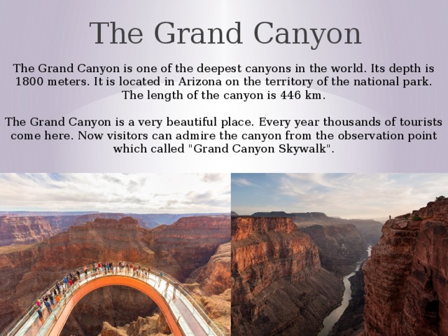
The Grand Canyon
The Grand Canyon is one of the deepest canyons in the world. Its depth is 1800 meters. It is located in Arizona on the territory of the national park. The length of the canyon is 446 km. The Grand Canyon is a very beautiful place. Every year thousands of tourists come here. Now visitors can admire the canyon from the observation point which called "Grand Canyon Skywalk".

Niagara Falls
Niagara Falls are located on the border between Canada and the USA. "Niagara Falls" is a common name for three waterfalls – the American Falls, the Horseshoe Falls and the Bridal Veil Falls. Niagara Falls are not very high (53 meters) but very wide. Every year thousands of people visit this place. There is the Rainbow Bridge over the river which connects both countries. It is open for people.

Death Valley
Death Valley is a desert valley located in Eastern California, in the northern Mojave Desert bordering the Great Basin Desert. It is one of the hottest places in the world at the height of summertime along with deserts in the Middle East. Death Valley's Badwater Basin is the point of the lowest elevation in North America, at 282 feet (86 m) below sea level. Death Valley also contains salt pans. The valley received its English name in 1849 during the California Gold Rush. It was called Death Valley by prospectors and others who sought to cross the valley on their way to the gold fields.

The Appalachian Mountains
The Appalachian Mountains, often called the Appalachians, are a system of mountains in eastern North America. The Appalachians first formed roughly 480 million years ago. The mountain range is mostly in the United States but it extends into southeastern Canada. The Appalachian Mountains, often called the Appalachians, are a system of mountains in eastern North America. The Appalachians first formed roughly 480 million years ago. The mountain range is mostly in the United States (U.S.) but it extends into southeastern Canada. The Appalachian Mountains contain major deposits of anthracite coal as well as bituminous coal.

Niagara River
The Niagara River is a river that flows north from Lake Erie to Lake Ontario. It forms part of the border between the province of Ontario in Canada (on the west) and the state of New York in the United States (on the east). The Niagara River also features two large islands and numerous smaller islands. Grand Island and Navy Island, the two largest islands, are on the American and Canadian sides of the river
Length
Basin size
58 km
684,000 km 2

Colorado River
The Colorado River is one of the principal rivers of the Southwestern United States and northern Mexico. Starting in the central Rocky Mountains of Colorado, the river flows generally southwest across the Colorado Plateau and through the Grand Canyon before reaching Lake Mead on the Arizona–Nevada border, where it turns south toward the international border . The Colorado is joined by over 25 significant tributaries. The drainage basin or watershed of the Colorado River encompasses 246,000 square miles (640,000 km 2 ) of southwestern North America, making it the seventh largest on the continent. The first humans of the Colorado River basin were likely Paleo-Indians of the Clovis and Folsom cultures, who first arrived on the Colorado Plateau about 12,000 years ago.

Great Plains
The Great Plains is the broad expanse of flat land (a plain), much of it covered in steppe and grassland, that lies west of the Mississippi River tallgrass prairie in the United States and east of the Rocky Mountains in the U.S. and Canada. The region is known for supporting extensive cattle ranching and dry farming . The Canadian portion of the Plains is known as the Prairies . The term "Great Plains" is used in the United States to describe a sub-section of the even more vast Interior Plains physiographic division, which covers much of the interior of North America. The region is about 500 mi (800 km) east to west and 2,000 mi (3,200 km) north to south. The Great Plains are part of the floristic North American Prairies Province , which extends from the Rocky Mountains to the Appalachians .

Mississippi River
The Mississippi River is the longest river of the United States and the chief river of the second-largest drainage system on the North American continent, second only to the Hudson Bay drainage system. Its source is Lake Itasca in northern Minnesota and it flows generally south for 2,320 miles (3,730 km) The Mississippi River can be divided into three sections: the Upper Mississippi, the Middle Mississippi, the Lower Mississippi. The Mississippi River is about 3 feet deep. The Mississippi has a length of 2,320 miles (3,730 km) The Mississippi River runs through or along 10 states, from Minnesota to Louisiana. About 375 fish species are known from the Mississippi basin.
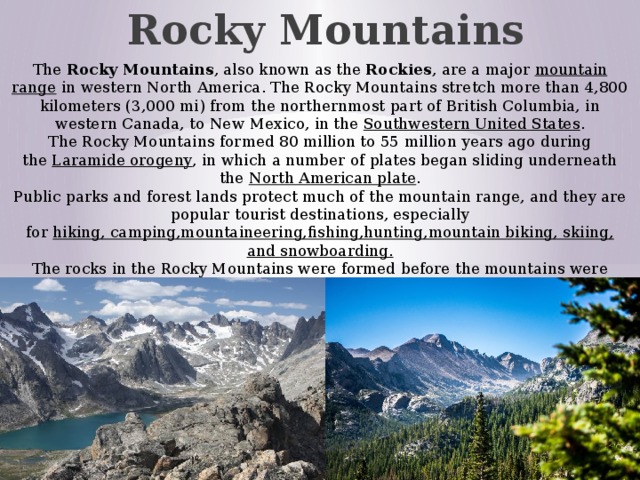
Rocky Mountains
The Rocky Mountains , also known as the Rockies , are a major mountain range in western North America. The Rocky Mountains stretch more than 4,800 kilometers (3,000 mi) from the northernmost part of British Columbia, in western Canada, to New Mexico, in the Southwestern United States . The Rocky Mountains formed 80 million to 55 million years ago during the Laramide orogeny , in which a number of plates began sliding underneath the North American plate . Public parks and forest lands protect much of the mountain range, and they are popular tourist destinations, especially for hiking, camping,mountaineering,fishing,hunting,mountain biking, skiing, and snowboarding. The rocks in the Rocky Mountains were formed before the mountains were raised by tectonic forces

Badwater Basin
Badwater Basin is an endorheic basin in Death Valley National Park, Death Valley, Inyo County, California, noted as the lowest point in North America, with a depth of 282 ft. (86 m) below sea level. Mount Whitney, the highest point in the contiguous 48 United States, is only 84.6 miles (136 km) to the northwest. The site itself consists of a small spring-fed pool of "bad water" next to the road in a sink; the accumulated salts of the surrounding basin make it undrinkable, thus giving it the name. The pool does have animal and plant life, including pickleweed, aquatic insects, and the Badwater snail. A popular site for tourists is the sign marking "sea level" on the cliff above the Badwater Basin. Adjacent to the pool, where water is not always present at the surface, repeated freeze–thaw and evaporation cycles gradually push the thin salt crust into hexagonal honeycomb shapes.


Вебинар для учителей

Свидетельство об участии БЕСПЛАТНО!